Context:
I. Mana River in Krasnoyarsk Krai
II. Maina urban settlement in Khakassia
I. Mana River in Krasnoyarsk Krai
Mana (length 475 km) is a river in Krasnoyarsk Krai (super region) of Russia. Its mouth is 12 km. from the city of Krasnoyarsk. At 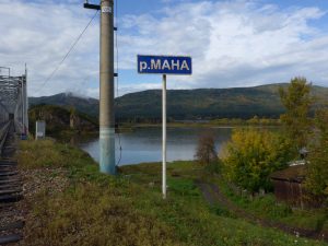 the spot where Mana River enters Yenisei River is the settlement of Ust-Mana. Its name literally means “mouth of River Mana”. Few kilometers south of settlement Ust-Mana is settlement Mansky. Mansky literally means “belonging to Mana”. In English, it is “Man
  + sky”. In the middle of the last century, they considered this territory as a place for Academic Town. On the cost of arm of Mana district is the main water artery, the beautiful Mana, one of the cleanest rivers of Krasnoyarsk Krai.
If the Russian name of Mana is literally read in English, it will sound as Maha (see the photo on the right). Maha is a Sanskrit word meaning «great«.
Ust-Mana and Mansky are parts of town of Divnogorsk, located on the Yenisei River, 30 km west from the border of the city of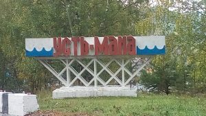 Krasnoyarsk. Divnogorsk’s main industrial facility is the Krasnoyarsk Dam on the
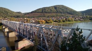 Yenisei River. From commissioning of 10th turbine in 1971, the station was the world’s single biggest power producer until 1983. It is a landmark symbol of Krasnoyarsk, and is depicted on the 10-ruble bill. As a result of the damming, the Krasnoyarsk Reservoir (informally the Krasnoyarsk Sea) was created. It is 388 km in length.
Krasnoyarsk coat of arms is a golden lion placed on a red heraldic shield with a spade in the right fore paw and a sickle in the left fore paw. 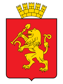 The shield is topped with the golden mural crown. The lion symbolizes strength and courage. The sickle
  and shovel initially reflected the main occupation of the inhabitants — farming and mining of minerals, primarily gold. In the 1840s the Yenisei province became the main center of gold mining in Siberia.
In the lower part of the coat of arms of the Kingdom of Manna is the head of a golden lion placed on a red heraldic shield.
The Kingdom of Manna existed in present day Iran (lit. «Land of Aryans») and Northern Azerbaijan in 1st millennium BCE, but none of toponymy or hydronym related to Manna is left. On the other hand, they are still present in Russia. Two rivers Maina in the Volga basin, plus river Mana is Southern Siberia. In Torah (the base of the Old Testament of the Bible), the term Mana (of Heaven) is used with one letter ‘n’. In the Bible, the Manna of Heaven has two letters ‘n’. Therefore, the river name Mana is fully related to Manna of Heaven or vice versa, taken into account the Lemurian exposure of Southern Siberia. The term ‘Mana’ is present in Sanskrit, the language of the oldest religious texts attributed to the Aryans who came to Hindustan and Iran in the 2nd millennium BCE from the territory of modern Russia. DNA genealogy states that the place of their origin was Southern Siberia.
Another golden lion on a red heraldic shield is on the coat of arms of the Russian city of Vladimir. Vladimir was the Russian capital before Moscow, i.e. during 12th – 14th centuries. Vladimir heritage is linked to Sanskrit, Atlantis and Lemuria (see below).
The coat of arms of the city of Vladimir (the lion) is one of the oldest in Russian heraldry. It  arose in the 12th century as a patrimonial sign of the Vladimir princes. The image of a lion is one of the most common plots in the decorative design of the world famous temples built on the Vladimir land in the 12th -14th centuries. As a rule, lion in heraldry symbolizes strength, courage, power.
On the eastern outskirt of Vladimir (or vice versa) is Sungir that was connected to the Lemurians over 26,000 years ago. Vladimir region is rich on the toponymy translated from Sanskrit. For instance: Rivers Agra and Tara, River Yada, etc. Even the lion on the Vladimir’s coat of arms resembles Indian half-man, half-lion Narasimha, an avatar of the Hindu god Vishnu, who saved his devotee Prahlada. The Narasimha-kavaca mantra is believed to be the most powerful and supreme of all other mantras. In Sanskrit, kavaca means ‘armor’. River Kava is in Tver region of Russia. It flows near village named Delhi, like the Indian capital.
The official currency of the Kingdom of Manna is the Aureus (“golden”) that is known as a gold coin of ancient Rome. The currency code used only within the Kingdom is AU. It is also the symbol of gold as a chemical element. Gold has atomic number 79, making it one of the higher atomic number elements that occur naturally. Interestingly, 79 is also the automobile code for the cars registered in Jewish Autonomous Oblast (region) of Russia. It is located in the Russian Far East and borders Heilongjiang province of China.
Heilongjiang literally means Black Dragon River, which is the Chinese name for the Amur. The Reptiles have played important role in human history. Au is also a frequent element in Germanic toponymy. The River Main (525 km) is the longest right tributary of the Rhine and the longest river lying entirely in Germany. Two rivers with the name Main are in Ulyanovsk region of Russia, where the leader of Russian revolution (1917) Vladimir Lenin was born in 1870.
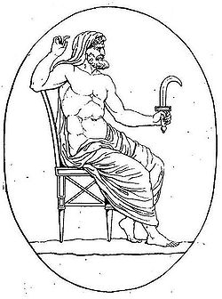 The sickle (of the Krasnoyarsk lion) is a multilevel symbol. In Greek mythology, the leader of Titans Cronos’ symbol was a sickle. His rule was the mythological Golden Age, until he was overthrown by his own son Zeus and imprisoned in Tartarus. In time, Cronos, the divine descendants of Uranus (the Sky) and Gaia (the Earth), became known as god of time or “Father Time”. His Roman variant, Saturn, has had a large influence on Western culture. The Saturnalia, a festival dedicated in his honour, was in fact celebration of the New Year.
In Russian, sickle is called serp. Serpuhov (town in Moscow region, rich of Sanskrit toponymy) has a lot of mysterious links with India (or vice versa, taken into account that the Aryans came to Hindustan in 2nd millennium BCE from the territory of modern Russia).
Since Cronos was a titan of the Harvest, it is interesting to note that the Law of One (The Ra Material) states that harvesting is the process through which the soul and / or the planet is “released” from one density to another. This is the possibility of Ascension, the completion of training, the exit from the trap of physical matter.
In the Harvest, all individuals are tested for their core ethical orientation for whether they evolve or not out of our third density existence, into a more refined fourth density. They have to decide what is most important in their lives – the polarities of “service to self” or “service to other”. The sickle is a well known symbol of hard working. The maim labor is self-improvement and self-development centered on the Creator and the service to others.
“Thrust in your sickle and reap, for the time has come for you to reap,
for the harvest of the earth is ripe.” — Revelations 14:15.
In the Ra Material and the Hidden Hand dialogue a spiritual evolution process is discussed as the Great Harvest. However, the Hidden Hand has also associated the Lord of the Harvest with retuning of Nibiru in 2012. It didn’t come to this dimension (time/space), but huge changes have been taking the place on Earth since that year, described in the Mayan Prophecies and their Calendar cycles.
Krasnoyarsk is an ancient place. Its history has several layers. The upper part refers to the current historical era. Everything below is related to the supercontinents existed on the planet hundreds of millions of years ago.
In 1969, just 260 km west of the mouth of the River Mana, was found the famous Tisulsky Princess, rested for hundreds of millions of years into a solid layer of coal. The time of her burial is thought to be at least 800 million years. Strictly speaking, it was the time of Rodinia supercontinent surrounded by Mirovoi superocean about 1 billion to 750 million years ago. Interpedently, both names Rodinia and Mirovoi (adopted by the world scientists) come from the Russian language. Rodinia is Rodina (Russian: “Motherland”) and Mirovoi means “global”, “embracing the whole world” (as it really was in case of this superocean). Interestingly, the name Odin is included in Rodina.
The finding was immediately classified by the authorities as the top secret. The people involved in the discovery are reported to die soon under mysterious circumstances.
Karnaukhov was the surname of miner who discovered the marble coffer with the princess. The two part of this old Russian surname are “Karna” and “Ukho”. In Russian, “Ukho” means “ear”. In Sanskrit, ear is karna. In a broader sense, it means capable of widely perceiving what is happening, not missing anything. Karna conquered the entire world. His father was Surya. Karna is one of the central characters in the major Hindu epic Mahabharata. Karna faced all the odds of his fortune with virtue and valor. He fought against misfortune throughout his life and kept his word under all circumstances. Being a great warrior, throughout his life, Karna only believed in his karma. In Russian mythology, the goddess of incarnation is Karna.
It is only about 470 km south of the mouth of the River Mana, the Lemurians discovered in the Sayan Mountains the cave with well preserved bodies of people who became the ancestors of the Atlanteans. It happened about 28,000 years ago. Near that place River Yenisei is formed. It is the largest river system flowing to the Arctic Ocean, associated with Arctic Hyperborea. Yenisei (3,438 km) is the central of the three great Siberian rivers that flow into the Arctic Ocean. The other two being the Ob (3,650 km) and the Lena (4,400 km).
Yenisei River is formed by confluence of two lesser rivers: Bii-Khem and Kaa-Khem. In the 17th century, the northern toponym Yenisei competed for some time in documents with the South Siberian name of this river – Kem. Eventually, the term Yenisei has replaced Kem.
The ancient Egyptians called their country Kemet. The meaning of Kemet has been much debated. It is believed that “Kemet” which means “Black” was attributed to the color of the soil of Ancient Egypt. It is a big question if the fertile land on the banks of the River Nile has black color. But, without a doubt, black is the color of coal on which Kemerovo region of Siberia (Russia) stands.
The World Channeling magazine №4 (2014) reveals the history of Lemurian Egypt that existed on the territory of the present Kemerovo region more than 17,000 years ago. Kemerovo region borders Krasnoyarsk region. The distance between the city of Kemerovo and the city of Krasnoyarsk / mouth of River Mana is about 400 km. The above mentioned Tisulsky Princess was found on the territory of Kemerovo region, near its border with Krasnoyarsk region. Kemerovo region is the birthplace of Alexei Leonov, the first man in the world who stepped into the open Cosmos from starship. Town Kemer (Turkey) is located on the Nile Meridian.
Kryon says that 27,500 years ago a separate Lemurian settlement appeared on the territory of modern Siberia, which was roughly called EGYPTos. For some time it became the focus of Lemurian spirituality, the center of metaphysical knowledge, the place of healing and the purpose of pilgrimage of the then inhabitants of the planet. The founder of that Egypt was the great sage Amon Ra whose body in Samadhi was discovered in the cave in the Sayan Mountains, near the place of formation of river Yenisei previously called Kem.
Ancient Egypt was a kind of “tracing-paper” of that, truly ancient, Lemurian Egypt. Some of the Lightworkers, who are awakening the deep memory of past incarnations, recall that particular Lemurian Egypt, not understanding some inconsistencies of these memories with the already existing knowledge of modern science. It is stated that 28,500 years ago, the Lemurian priests, after training in the capital of Lemuria (the city of Yaruslim), were trained at the Amon-Ra Ashram, in the ancient Lemurian Egypt (the territory of South-West Siberia) under the leadership of the Great Sage Amon-Ra. The colony Aigaptus (Egypt) existed in the North of Africa during the Atlanteans. Later, in the days of Eurasian Hyperborea, in the same place there was a state with about the same name.
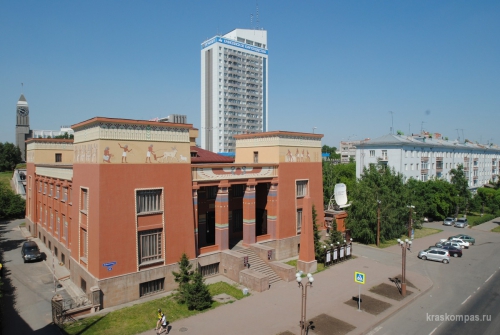 Name Krasnoyarsk means Krasny Yar (Red high unflooded river bank). Yar is the name of Yaruslim, the Lemurian capital. Lemuria had many ties with the territory of modern
  Russia, including the above mentioned place Sungir near Vladimir, the previous capital of Russia. As a recall from the time of Lemurian Egypt, could be the shape of Krasnoyarsk local history museum (founded in 1889) stylized as the ancient Egyptian temple.
Located on the bank of River Yenisei / Kem, it resembles the famous temple in 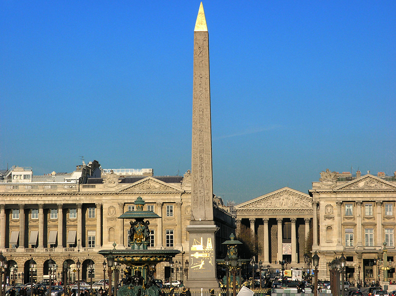 Luxor, located on the bank of Nile. By the way, in Latin, Lux means Light. The construction of Egyptian bulging of Krasnoyarsk local history museum started in 1913 and was finished in 1929. It is one of the oldest museums in Siberia and the Far East, one of the largest museums in Russia.

Practically, on the backyard of the museum is the so called Krasnoyarsk Big Ben (opened in 2001), the clock tower in front of the building of the city administration. This is one of the most important towers of Krasnoyarsk. Without the clock, it would rather remind the Luxor Obelisk standing at the centre of the Place de la Concorde in Paris, the main square of the French capital. Originally, the obelisk was located at the entrance to Luxor Temple, in Egypt. The remaining obelisk is at Luxor.
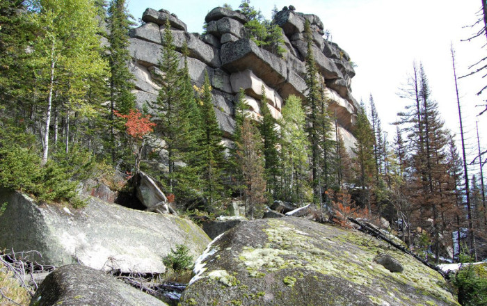
It is believed that Krasnoyarsk is located on the territory of a special portal connecting the planet with the higher dimensions. The _%D0%BC%D0%BE%D0%B5.jpg) city is notable for its nature landscapes. The Krasnoyarsk Pillars (bordering the River Mana, a favorite recreation place for Krasnoyarsk residents and many tourists from different countries; the most spectacular loops River Mana makes near its mouth in settlement ManSky) are stone remains and megalithic structures that are also believed to
city is notable for its nature landscapes. The Krasnoyarsk Pillars (bordering the River Mana, a favorite recreation place for Krasnoyarsk residents and many tourists from different countries; the most spectacular loops River Mana makes near its mouth in settlement ManSky) are stone remains and megalithic structures that are also believed to 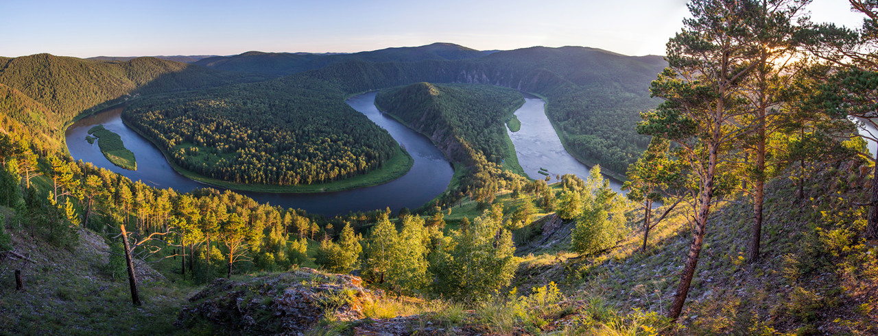 be made / used by previous civilizations with the purpose of using this place for moving between the worlds. Even a simple stay next to such a portal stimulates the growth and development of a person’s consciousness. At one life cycle of incarnation it is possible to make a huge leap.
Here, in Krasnoyarsk and its surroundings, there are all the conditions for the beginning of the creation of the next civilization on Earth that will be the stronghold of the Power of Light. The portal would help to pull the planet into higher spheres. It is a certain analogy with the Harvest process described the in The Ra Material (see above).
In Russia, from the distant times Procopius has been called the Reaper, since on the day of his memory (July 21) harvest begins.  Also, it is the day of the Kazan Icon of the Mother of God. It is the only icon of Our Lady being brought to Cosmos (2011). Not by accident, the crew of the Apollo 11 spacecraft arrived on the Moon on July 20, but entered its surface only on July 21.
11 is the number of the sign of Aquarius in the Zodiac. Aquarius is a sign of universal connection, contact and consciousness. Krasnoyarsk is located on the 56 north meridian. 5 is the number of Microcosm, whereas 6 is the number of Macrocosm. Together they are 11. Humanity and the whole Earth are entering the Age of Aquarius. Its capital will be Veliky Ustyug. The ancestor of the Russian Imperial House Procopius the Rightful chose in 12th century Veliky Ustyug as the place of his spiritual deed.
II. Maina urban settlement in Khakassia
Urban-type settlement of Maina (see below) is located on the River Yenisei, on the border of Krasnoyarsk region and the Republic of Khakassia passing along the River Yenisei.
Until 1991, Khakassia was administratively subordinated to Krasnoyarsk region. In 1992, it became the Republic of Khakassia. The most known ancient dwellers of the Khakassian steppes were Scythians who are considered to be the ancestors of Russians. Large body of evidence suggests that Siberian Scythians were also the ancestors of the local Turkic people. The ethnic Russians today make up ~82% of Khakassia’s population.
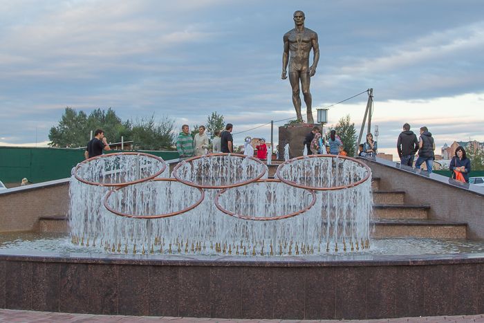 Among the most famous residents of Krasnoyarsk and Abakan is Russian heavyweight freestyle wrestler Ivan Yarygin (1948 – 1997). In 1973 Yarygin became the absolute champion of the USSR in freestyle wrestling. Along with Greco-Roman, it is one of the two styles of wrestling contested in the Olympic games. For a powerful, aggressive style of fighting, he was nicknamed «Ivan Grozny» (the Terrible). That year (1973) two Soviet films related to the first Russian Tsar Ivan Grozny were realized: “Ivan Vasilievich Changes His Profession” and “Red Kalina” (The Red Snowball Tree). Kalina is a popular Slavic motive.
In 1973 the Soviet Union started to get huge oil incomes from Samotlor Field, the largest oil field of Russia and one of largest in the world. To develop Samotlor, city of Nizhnevartovsk was established. It lies on one parallel with Saint-Petersburg, Kirillov and Veliky Ustyug. It is said that Samotlor extended the life of the Soviet Union (its deep reforms). The Soviet Union sold most of its oil and natural gas exports for United States dollars that were used to pay for grain and capital goods imports, as well as to support client states. Presumably, oil from Samotlor brought about $245 billion to the state budget, while the development and operation costs did not exceed $27 billion.
The World Trade Center (1973–2001) built in Lower Manhattan, was also open in 1973. Originally, the Twin Towers were the tallest buildings in the world. Metaphysically, they represented the might of material world dominated on the planet within the Great Experiment. Today, Earth and the whole Galaxy are experiencing the Age of Aquarius. In the Zodiac it has symbolic number 11.
Ivan Yarygin is the only athlete in the history of freestyle wrestling, who managed to put all competitors without exception on the shoulder blades in the three most prestigious competitions: the Olympic Games, the World Championships and the European Championships. His name Ivan read from the right to the left, becomes Navi. Ivan Yarygin was born in Kemerovo region, like Alexei Leonov, who was the first man to walk in Cosmos.
Ivan Yarygin attended his school in village Sizaya (Eng. «dove-colored») of Shushenskoye district (see below). He has built there a remarkable church, fulfilling the dream of his mother. The construction of the church was finished in the summer of 1999 and on August 20 it was consecrated in honor of the reverend Evdokia the Grand Duchess of Moscow, the patron saint of the mother of the Olympic champion Evdokia Yarygina. Grand Duck of Moscow Dmitri Ivanovich of Don (1350 – 1389) was the husband of saint Evdokia the Grand Duchess of Moscow. The river Don’s mouth Norwegian explorer Thor Heyerdahl has identified as the place of Asgard, the adore of Odin and his gods.
Village Sizaya is located just on the other bank of the Yenisei river opposite to the settlement of Maina.
Maina
 Urban-type settlement of Maina is located on the bank of Yenisei River. Maina
 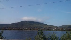 hydroelectric power station is a counter-regulator of the Sayano-Shushenskaya hydroelectric power station, smoothing the fluctuations in the water level in the Yenisei that arise when the operating modes of this powerful Sayano-Shushenskaya HPP are changed (see below).
Maina and Sayano-Shushenskaya HPPs are a single hydropower complex. As per the technical level, this complex does not have 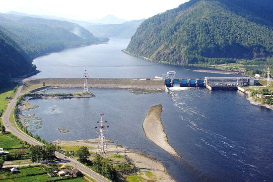 any analogs in Russia. During the year and during the day, the electricity needs are different. Therefore, Sayano-Shushenskaya hydroelectric station (peak HPP) must respond quickly to these fluctuations. Constant fluctuations in the water
level would cause inconveniences for water users of settlements located downstream, if there wasn’t here Maina hydroelectric power station. The direct distance between Maina and Sayano-Shushenskaya HPPs is less than 20 km.
Maina has less than five thousand residents and is a part of town of Sayanogorsk, located on the left bank of the Yenisei River. Another part of this town is Cheryomushki (lit. bird-cherry), an urban-type settlement of hydraulic engineers and operators of the largest in Russia Sayano-Shushenskaya HPP.
The Sayano–Shushenskaya Dam
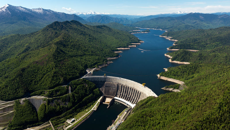 Sayano-Shushenskaya hydroelectric power station is the largest power plant in Russia and the 9th largest hydroelectric plant in the world, by average power generation. The dam supports the Sayano–Shushenskoe reservoir with surface area of 621 km2.
The first largest hydroelectricity facility in the world was named after former U.S. Herbert Hoover who had worked as an engineer in Russia (the Urals) before the 1917 revolution. Located on the Colorado River (Spanish: Red River), the modern Hoover Dam has also its own secrets related to the Insider (Hidden Hand) and the Pleiades.
The name of Sayano-Shushenskaya HPP is derived from the Sayan Mountains and the world famous urban-type settlement of Shushenskoye, Lenin’s Siberian exile, located ~70 km from the Sayano-Shushenskaya Dam and ~45 km of the above Maina.
During the Soviet times it was one of the major ideological destinations. Founder of the USSR Vladimir Lenin (1870 – 1924) was  in exile here for 3 years, from 1897 to 1900. He also got married here in 1898. Lenin was one of two persons in the 20th century who were given the title of Mahatma.
Shushenskoye still has got its own airport, although the population is only around seventeen thousand people. The airport used to be very busy, 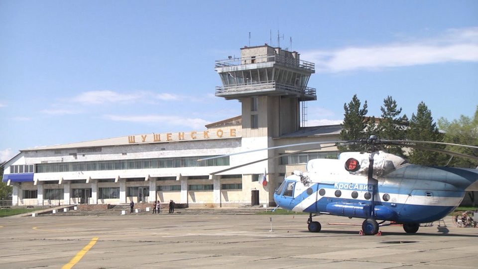 including the international flights. Many visitors from all over the Soviet Union and abroad would come here. In 1970, they opened a large museum-reserve dedicated to Lenin’s time in Shushenskoye (Siberia).
During the exile in Shushenskoye, Lenin wrote there about 30 articles, including “The Development of Capitalism in Russia”. Shushenskoye is located at the confluence of local river Big Shush with large Yenisei River.
On the other side of the Yenisei, there is village Kirovo named after famous revolutionary Sergei Kirov, whose surname descends to the name of Persian king Kir or Cyrus the Great (600 – 530 BCE). Lenin often visited that village for fishing and hunting. At that time it was called Novo-Voznesenskaya (New Ascension). Kirovo is a part of the Altai region of Khakassia. Altai mountains is a very important sacral place on the planet. Today Kirovo is a large producer of buckwheat in Siberia and the Far East.
Urban-type settlement Shushenskoye is ~45 km is from Abakan, the capital of Khakassia.
Abakan
Abakan is the capital of Republic of Khakassia. Its symbol is the lady holding a bowl. The true meaning of the symbol of the Bowl is the acceptance and accumulation of spiritual gifts that are used to serve the world. The most known is the sacred Bowl of Buddha. Surely, Abakan and Khakassia have these gifts. It is proved by their history and location.
Abakan is ~280 km. south west of Krasnoyarsk. Both cities are located on Yenisei / Kem River. Abakan stands in the mouth of River Abakan (tributary of Yenisei).
Abakan is ~230 km south west from the source of River Mana, whose mouth is near Krasnoyarsk. Practically, on the same distance west of Abakan are the megalithic structures of Gornaya Shoria (Mountainous Shoria) at the junction of Altai, Sayan and Kuznetsk Alatau mountains. It is the southern part of Kemerovo region (southern Siberia). It is famous today for the megalithic structures.
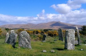 The area around the above mentioned city of Abakan is full of ancient menhirs. Typically, these menhirs are vertically buried in the ground stone slabs. They could be up to three meters high and over one meter wide. These ancient stone sculptures have a sacred meaning. Similar structures are present in Western Europe and the Scottish island of Lewis of Harris.
The coat of arms of Abakan depicts three golden ancient statues. It is 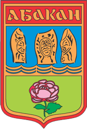 believed that these mysterious stone statues (menhirs) were erected by people who lived here about 4,000 years ago.
The name of the city of Abakan is connected with the Abakan River (514 km), which enters the River Yenisey in the city. The Abakan River originates on the northern slopes of the Western Sayan and the Altai Mountains.
 The very name Abakan could be connected with Sanskrit. It is present in other Russian places where toponymy is translated from Sanskrit. For instance, village Abakanovo (meaning Little Abakan) is located in Tver region. The direct distance between Abakan (Khakassia) and Abakanovo (Tver region) is 3,700 km. or 4,700 km by road.
Abakanovo (Tver region) is 30 km. from the source of the River Western Dvina. Its sister, the river Northern Dvina starts near Veliky Ustyug, by the confluence of the rivers Sukhona and the Yug, whose names are also easily translated from Sanskrit. Veliky Ustyug is a part of Vologda region, where there are 3 villages named Abakanovo.
It is no accident that the Valdai is located on the territory of the Tver region, on which the great rivers of the planet originate: the Volga, the Dnieper, the Desna, the Western Dvina, and others. Their names are translated from Sanskrit.
45 km Northwest of Abakan is the Salbyksky mound (Salbyk mound) officially attributed by the scientists to the Tagar culture that was a Bronze Age archeological culture flourished between the 8th and 2nd centuries BCE in South Siberia (modern Khakassia, southern part of Krasnoyarsk region, eastern part of Kemerovo region). The place is called “Valley of the Kings”. It is at the foot of the spurs of the mountain ridge of the Kuznetsk Alatau. In the valley there are more than 100 burial mounds of Tagar culture of Scythian time. 15 of them belong to the so called large mounds (diameter more than 50 meters). Most of them are still unexplored. Tagar civilization was one of the largest centers of bronze-smelting in ancient Eurasia.
Tagar culture was a Bronze Age archaeological culture which flourished between the 8th and 2nd centuries BCE in South Siberia (Khakassia, southern part of Krasnoyarsk Krai, eastern part of Kemerovo region). The culture was named after the Tagara Island in the Yenisei River opposite Minusinsk, just 8 km east from Abakan. Nearby Minusinsk, there is the Lake Tagara. Also, village Tagara located on the originated from the Lake Baikal the River Angara (a major tributary of the Yenisei), is 480 km north east from Krasnoyarsk.
Tagara is a Sanskrit word referring to “valerian”, a herb from the Valerianaceae family, and is used throughout Ayurvedic practices. Tagara is a natural sedative, also called Indian valerian. This fuzzy plant grows in the Himalayas, separating the plains of the Indian subcontinent from the Tibetan Plateau. The Earth’s highest peak (Mount Everest) is in the the Himalayas. The roots of the plant smell pleasant, giving off an aromatic oil containing valeric acid. As a traditional medicine, it is used in various recipes and used against sleep problems, obesity and other issues.
The Tagars were Indo-Europeans, predominantly light-eyed and light haired. They produced animal art motifs (Scythian art) very similar to the Scythians of southern European Russia. The huge royal mounds (kurgans) fenced by stone plaques, with four vertical stelae marking the corners is thought to be the most striking feature of the Tagar culture.
Once in the past, the Great Salbyksky mound was a four-edged earth pyramid, surrounded by a stone fence. As per today the mound is gone. It was excavated in 1954-1956 during the scientific exploration.
Before the excavation, the stone fence of the mound was almost invisible beneath the frayed floors of the mound. On the surface there were only angular  plates. At the beginning of the excavation, the height of the mound reached 11.5 meters. The length of the stone fence was 71 m. The earth embankment / tetrahedral pyramid initially reached a height of approximately up to 25 m.
In the Salbyk steppe, in a radius of about 5 km from Great Salbyksky mound, there are 56 mounds, 5 of which are only slightly smaller than the Great Salbyksky mound, and the height of the rest is 4-6 m. A characteristic feature for the Salbyk group of mounds is their pyramidal form.
Under the pyramid of the Great Salbyksky mound they found a square pit of 5 x 5 meters, and depth of 1.8 meters. Its walls were furnished with vertical logs. In the crypt they discovered 7 men and women. An old warrior was buried in the center. World Channeling magazine describes how Scythian burial mounds of their ancestors helped them communicate with higher dimensions and got the power to defeat their enemies.
The burial under the Great Salbyksky mound could be of Tagar (Scythian) culture. No doubt that they could build the earth mound. But it does not necessary mean that they erected numerous heavy stone monoliths around the mounds approximately 2,400 years ago. It well could have been erected before them.
 The height of vertically standing monoliths reaches 6 meters, plus at least 1 meter should be below the surface (otherwise they could not keep the upright position). The weight of stone monoliths fluctuates from 30 to 50 tons. It is suggested that the Scythians transported them from the quarries on the banks of the Yenisei River located 70 km from the mounds. None of the archaeologists involved can explain and show what transportation means were used. Even today,
  it would be a challenge for the modern powerful machinery like big tracks, excavators, and cranes.
At that time Scythians could rely only on their horses and male hands. It would be simply an impossible and illogical task for them. Compare a horseman on the top of the Great Salbyksky mound with the surrounding stone monoliths. Moreover, many of the stones bear the traces of unknown instruments in form of ideally straight lines.
The ancient toponymy here is Indo-European. The Salbyk mounds are located on the territory of Vershino-Bija village council. In Russian, Vershina is the summit, the crown. In Sanskrit, Bija means “seed” and is used as a metaphor for the origin or cause of things. The best-known Bija syllable is Om, the most sacred sound in Hinduism. Bija is a major religious and philosophical concept in Buddhism and Hinduism. Hindus believe that the vibration of the sacral sound OM created the Universe.
River Bija originates on the outskirt of village Vershino-Bija (16 km from the Great Salbyksky mound). 5 km east from the source of River Bija is the source of River Harasug. In Sanskrit, hara means “yellow” as well as “gold”. This region used to be a major gold mining place of the Russian Empire. In Iranian Avesta, Hara Berezaiti is the World Mountain, same as the Mount Meru of Indian sacred texts. Also, in Hinduism Hara is an early name of the god Shiva from the Harappan culture (Indus Valley Civilization). In Sanskrit, Shiva is Siva. The largest settlement in the valley of the Russian river Siva is the city of Votkinsk.
 Another evidence of the antiquity of the names around Abakan is the local Tasheba River (a tributary of the Yenisei). Teisheba is the Urartian god of thunder and war. He is a counterpart to the Assyrian god Adad, the Vedic God Indra, and the Hurrian god, Teshub. The Hurrians tribes represented a large ethnic component in the region of Lake Urmia, where the Manna kingdom was formed in the 1st millennium BCE.
The Hurrians appeared on the territory of northern Mesopotamia in the second half of the 3rd millennium BCE. In Syria and Mesopotamia they lived alternately with the Semites and in the 16th — 13th centuries BCE. The Hurrians created the state of Mitanni, the motherland of the mother and wife of pharaoh and religious reformer Akhenaton. The Hurrians’ power included Syrian Aleppo. The Hurrians exerted a strong influence on the Hittite kingdom. The capital of Mitanni was located on the source of the river Habur, also known as the “River of Babylon” in the biblical history of the so called Babylonian captivity. River Habur originates in the southeast of Turkey, and in Syria it flows into the Euphrates.
There is a version that the god Teisheba was a Urartian analogue of the Assyrian god Adad. Adad (Sumer Ishkur) was the youngest son of Enlil, who was not only the leader of the Nibiruan mission on Earth, but was also the Crown Prince of Nibiru.
To the north of Abakan lies the village of Kalinino, beyond the above-mentioned river Tasheba. The very ancient root of the village’s name could not only be in folk popular motive of Kalina (red colour viburnum or guelder rose), but also in Kali.
 The world’s oldest astronomical observatory is located in Khakassia. The observatory’s age comes to almost
18,000 years. For instance, the estimated age of English Stonehenge is only 5,000 years. So, the Khakassian observatory, called Sunduki (English: Chests), is older more than 3,5 times.
The Sunduki are 8 sandstone mounts that rise majestically from the steppe. Total length is 10 km. The area is 2,100 hectares. The Sunduki are over 370 million years old. The White horse Petroglyph is 18,000 years old. On the territory of the reserve there are more than 200 sanctuary-calendars.
The Sunduki was a place of huge religious significance in the ancient world. Still it has high spiritual and energetic significance for shamans and people with paranormal abilities. They are often visitors here. The Sunduki are located 150 km North West of Abakan, near the border with Krasnoyarsk region.
 It is only 13 km from the Sunduki to the so called Siberian Dead Sea that is the Lake Tus. It is the most exotic lake in Eastern Siberia. The concentration of the salt (essence of life) is so high that it is impossible to dive or sink. The name of the lake is clearly Aryan or the so called Indo-European or Indo-Iranian. In modern day Iran, there is town of Tus. To the ancient Greeks, it was known as Susia. Compare it to the name of Shushenskoye on Sush river.
The most famous person who was born in Iranian Tus is the poet Ferdowsi (c. 940 – 1020), author of the Persian epic Shahnameh (“The Book of Kings”). It is the world’s longest epic poem created by a single poet, and the national epic of Greater Iran, a monument of poetry and historiography. It describes Iran’s (“land of Aryans”) ancient history from the creation of the world until the Islamic conquest of Persia (Iran) in the 7th century. Modern Iran, Azerbaijan, Afghanistan and the greater region formerly influenced by the Persian culture celebrate this national epic. Among these countries are Armenia, Dagestan, Georgia, Turkey, etc. Iranian town of Tus is also the place of many famous theologians, philosophers, mystics, poets, etc.
25 km South East from the lake Tus is another prominent Lake Shira (Sira). In Sanskrit, Sir means “Head”. Strange slabs going into the lake have been found on the South Western bank. At a depth of 5 to 10 meters, researchers have also found fragments of giant stone slabs. On the eastern side, 15 slabs with cut ends have been found. Obviously, no natural phenomenon can produce rectangles and lay them in a dense cover along the shore of the lake.
X-ray-luminescent analysis of pieces of plates has revealed that they have a complex structure that includes silicon, aluminum, magnesium, iron, strontium, niobium, and yttrium. Experts say that such complex alloys are used only in the space and military industries.
Appendix 1
 The Krasnoyarsk Krai lies in the middle of Russia and Siberia. It is among the richest of Russia’s regions in natural resources. 80% of the country’s nickel, 75% of its cobalt, 70% of its copper, 16% of its coal, and 10% of its gold are extracted here. The Krasnoyarsk Krai also produces 20% of the country’s timber. More than 95% of Russian resources of platinum and platinoids are concentrated in the Krasnoyarsk Krai.
The city of Krasnoyarsk is the 3rd largest city in Siberia (after Novosibirsk and Omsk). Krasnoyarsk Krai is the largest krai (super region) in the Russian Federation and the second largest Russian federal subject (after the Saha Republic). Also, Krasnoyarsk Krai is the third largest subnational governing body by area in the world, after the Saha Republic of Russia and the Australian state of Western Australia.
Krasnoyarsk Krai covers an area of 2,3 mln. km2 which is nearly one quarter of Canada (the next-largest country in the world after Russia). Krasnoyarsk Krai constitute roughly 13% of the Russian Federation’s total area. The population of Krasnoyarsk Krai is over 2,8 million people, or just under 2% of Russia. Krasnoyarsk is the site of the Siberian Federal University, one of the four largest educational institutions of Russia.
The two most powerful hydroelectric plants in Russia are built on the Yenisei River. The Krasnoyarsk Krai is one of the most important producers of electric energy in Russia.
Krasnoyarsk Krai is located in the basin of the Arctic Ocean. A great number of rivers (tributaries of Yenisei) that flow through the Krai drain eventually into the Arctic Ocean. One of them is Podkamennaya Tunguska, the world famous river for the so called meteorite explosion in its basin happened in 1908 and flattened more than 2,000 km2 of pine forest and knocked down some 80 million trees. The estimates of the energy of the air burst vary from 5 to 30 megatons of TNT. The 15 megaton estimate represents energy about 1000 times greater than that of the atomic bomb dropped on Hiroshima, Japan. Magazine «World Channeling» №7 (39) 2017 states that it was special energy arrival to Earth. The area was very important in the time of Lemuria (26,000 years ago). This is a special portal on the planet.
According to official history and archaeology, the traces of first people in Siberia are circa 40,000 BCE. The first modern Russian settlements in Krasnoyarsk Krai (mostly by Cossacks) began in the 17th century. However, the Scythians (descendants of the Aryans, like the modern Russians) lived here 2,500 year ago. They were a nomadic people who lived in the 1st millennium BCE on a vast territory from Southern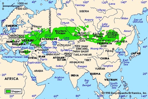 Siberia to the Black Sea region. The eastern border of the Aryan living space was Manchuria (Northmen China) and modern Russian city and port of Vladivostok (lit.»One who rules the East») on the Pacific Ocean. The Scythians are considered one of the progenitors of the Slavic and Eastern European tribes. The grave-mounds and monuments of the Scythian culture in Krasnoyarsk Krai are among the oldest in Eurasia. Only in the Khakassia steppes the Scythians have left 100,000 burial mounds with the burials of their kings.
Famous Scythian burial mounds are also located in southern Kazakhstan in the region of Almaty. The so called Scythian «golden man» has been adopted as one of the symbols of modern Kazakhstan.
The Scythians were dominated almost a millennium on the present territory of Russia (Soviet Union and Russian Empire). They could not be defeated neither by the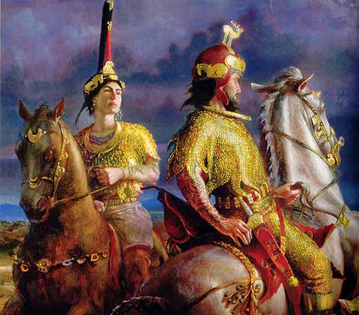 empire of the Persians, nor by Alexander the Great. The Scythians is the Greek word by which the Hellenes designated nomadic peoples living on the territory of the Black Sea region between the rivers Don and the Danube. The Russian River Don is famous for its brave Cossacks. The Don’s mouth Norwegian explorer Thor Heyerdahl has identified as the place of Asgard, the adore of Odin and his gods.
Scythians called themselves Saka or Saki. Presumably, the ancestors of Buddha Shakyamuni (or Sakyamuni) were Saki / Saky. In the mid-3rd century BCE the Indian Emperor Ashoka determined that Lumbini (present-day Nepal) was Gautama’s birthplace and thus installed a pillar there with the inscription: “…this is where the Buddha, sage of the Sakyas (Sakyamuni), was born”.
The current center of Russian federation is located on the north of the Krasnoyarsk Krai. It is the Putorana Plateau bordering the Taymyr Peninsula that forms the northernmost part of the mainland of Eurasia. The nearest major settlement is the city of Norilsk, the world’s northernmost city with more than 100,000 inhabitants and the second-largest city (after Russian city of Murmansk) inside the Arctic Circle. Norilsk is located at the foot of the Putorana Mountains, on some of the largest nickel deposits on Earth. The nickel deposits of Norilsk are the largest-known nickel-copper-palladium deposits in the world.
330 km south of Norilsk, the village of Kureika (just north of the Arctic Circle near town of Turukhansk) Joseph Stalin spent his final exile in 1914 — 1916. Kureika is located the on the confluence of Kureika River and Yenisei.
During both the Russian Empire and the Soviet Union, the territory of Krasnoyarsk Krai was used as a place of exile of political enemies. The first leaders of the Soviet state, Vladimir Lenin and Joseph Stalin were exiled here. In Krasnoyarsk Krai was in exile Gleb Krzhizhanovsky, a close friend of Lenin. He was a Soviet Scientist and a state figure, who was appointed as a Chief of Russia Electrification Commission in 1920 and led the first Soviet plan for national economic recovery and development under the supervision of Lenin. Lenin’s belief in the central importance of electrification to the achievement of communism is represented by his statement that: “Communism is Soviet government plus the electrification of the whole country”.
Appendix 2
In the 1950s, mouth of River Mana was considered as a place for Academic Town. It is a Soviet tradition rooted in the Greek heritage. The term “Academy” was first introduced in ancient Hellas and belonged to the Athenian grove, walking in which Plato spoke with the students. After a couple of thousand years, the Soviet Union traditionally built its world known Academic Towns at a distance from the city center, in the bosom of nature, surrounded by groves and forests.
 Finally, they decided to found the Academic Town on the western outskirts of the city of Krasnoyarsk, on the last vertex of the Sayan ridge, on the other bank of the Yenisei River. Steep bank, towering a hundred meters above the Yenisei, was chosen as the birthplace of the scientific nucleus.
Krasnoyarsk Academic Town began in 20th century with a dendrarium to create a healthier, privileged enclave for academics to live in, among trees and vegetation and outside of the dirtier industrial areas. New large brick seven-dome church with a bell tower in Russian style was built here in 21st century. It is dedicated to the last Russian Tsar Nicholas II and his family. While being a prince he visited Krasnoyarsk on his journey to the Far East.

The Rock of Manskaya baba (lady of Mana)
The Academic Town is directly opposite to the state protected Stolby Nature Sanctuary on the other bank of Yenisei. The site is known for its spectacular complexes of rocks. This strict ecological reserve is located practically on the west-southern outskirts of the city of Krasnoyarsk. The lower part of River Mana (near its conjunction with Yenisei) is the natural border of Stolby Nature Sanctuary. The Stolby has been nominated to be on the list of UNESCO World Heritage Sites. The Rock of Manskaya baba (lady of Mana) is one the most spectacular of them. It is also called the Queen of the Stolby. In Russian, baba means ‘lady’, including old lady (babushka). Baba is a word found in several Middle Eastern and Asian languages, including Sanskrit and Hindi with meaning «father», «grandfather», «wise old man», etc. It is used as a form of address to show respect for a spiritual teacher or an older man.
The direct distance between the mouth of Mana and the Krasnoyarsk Academic Town (Akademgorodok) is 20 km. Krasnoyarsk Academic Town’s elder brother and prototype is Novosibirsk Academic Town located 630 km west, on the bank of Ob river (3,650 km), the world’s 7th longest river. The Ob originates in the Altay Mountains, bursting out of a glacier on Mount Belukha believed to be connected with Shambala. The Ob is the westernmost of the three great Siberian Rivers that flow into the Arctic Ocean (the other two being the Yenisei River and the Lena River).
The oldest institute of Krasnoyarsk Academic Town is the Forest Institute established in 1944. The Institute of Physics was established in 1956. The Institute of Computational Modeling SB RAS was established in 1975. The Institute of Biophysics was established in 1981.
Appendix 3
Southern Siberia & DNA Genealogy
DNA genealogy developed by Russian scholar and visionary Anatole Klyosov has enabled to reconstruct migration, settlement patterns and evolution of populations in ancient Europe and other countries. It is a new field of science, which is currently emerging as a blend of biochemistry, history, linguistics, and chemical kinetics, etc. Unlike the description of different nations made by the ancient authors and invented interpretations, which in the absence of facts are often “compensated” by passionate fantasy, DNA genealogy is precise and consistent with objective scientific data.
According to DNA genealogy, haplogroup R1a (attributed to the Aryans) arose apparently in South Siberia and/or neighboring regions around 20,000 years ago. Not later than 12,000 years ago bearers of R1a1 already were in the Hindustan, then went across Anatolia and the rest of Asia Minor apparently between 10,000 and 9,000 years ago, and around 9,000 – 8,000 years ago they arrived to the Balkans and spread over Europe, bringing proto-Indo-European and Indo-European languages.
In 4,800 years ago they migrated eastward from Europe to the Russian Plane and then to India. About 3,000 – 2,500 years ago they migrated with their Indo-European languages from the Russian Plain back to central, western, and southern Europe, laying the genetic groundwork for peoples later called Celts, Germans, Italics, Greeks, Illyrians, and Balto-Slavs.
During the 1st Millennium BCE and the first centuries of our era the Scythians, mainly the carriers of haplogroup R1a, moved partly to Europe up to the Atlantic. The rest settled on the territory of Kazakhstan, the southern Urals, Central Asia up to the Altai, and now here continue to live their descendants – Kyrgyz, Kazakhs, Bashkirs, Uzbeks, Tajiks, Khakassia, Tuva, the Altai-Kizhi (Kizhi is also a famous place in the Onega Lake of Russia) and others. They differ today, but are the descendants of Aryan common ancestors. The Scythians of the West continue to live as a modern Western and Eastern Slavs, the population of Central and Eastern Europe belong to haplogroup R1a.
The future Aryans, bearers of haplogroup R1a, about 10,000 – 8,000 years ago arrived in Europe, after a long migration across the Southern Arc, from Central Asia, through Tibet, Northern Hindustan, the Iranian plateau, Anatolia, the Balkans. Then, according to DNA genealogy, Aryans moved from Europe to the Russian plain about 4800 years ago.
About 4500 years ago, Aryans began to diverge from the Russian plain in different directions — to the South (through the Caucasus to Mesopotamia, the Middle East and further to the Arabian Peninsula up to the Indian ocean, about 4000-3600 years ago; in the Arab world, the share of haplogroup R1a now reaches 9% of the population by region; there, on the territory of modern Syria, recorded ancient Mitanni Aryans), to the Southeast (in the mountains of Central Asia about 4,000 years ago, and then, after about 500 years, on the Iranian plateau, as the Avestian Aryans), to the southern Urals about 4,000 years ago (and then to the South, in Hindustan, about 3,500 years ago, as Indo-Aryans.
Naturally, not all Aryans left the Russian plain. The remaining carriers of haplogroup R1a were in the South of Russia and Ukraine, in the Caucasus, in the Caspian steppes, in Central Asia, as well as in the Balkans (ancestors of Serbs, for example). According to the ancient Greek definition of Scythians, all of them were Scythians.
The Aryans-Scythians were in the East even further, beyond the sacral Urals, where they arrived about 4,000 years ago. Their ancient settlement of Arkaim existed between 3800-3600 years ago. The Aryans were in the Khakassia already 3800-3400 years ago. The distance between Arkaim and Abakan (capital of Khakassia) is more than 2,000 km. According to the traditional historical classification they were early Scythians. So, late Aryans are early Scythians. In fact, one genus, one population.
By that time the Aryans-Scythians had already moved 4,000 km beyond the Urals. If they have gone with the usual speed for ancient migrations of 1 km per year, then it would have taken them 4,000 years for such a transition. The Scythians ran the distance for a few hundred years. It is clear that they did not go on foot. They had horses and wheeled transport.
Studies reveal that the Eastern Slavs and Scythians of Khakassia are one genus (R1a) and have direct and fairly close relationship at the level of haplotypes. The common ancestor of the Slavs on the Russian plain (4800 years ago) and the Scythians (3800-3400 years ago) lived 4600 — 4400 years ago. It is the time of the beginning of Aryan migrations from the Russian plain. The haplogroup R1a reaches 72% in Indian higher castes.
Appendix 4
The Kemerovo region megalithic structures could be described as follows:
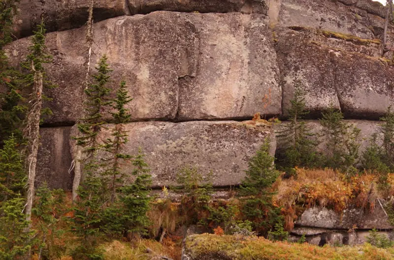
- The walls are laid out of giant stone blocks. Here also there are strange buildings with vertically installed stone obelisks.
- Some granite blocks at the bottom have been made of red granite and crowned with blocks of gray granite, and above lay polygonal masonry from various blocks of both red and gray granite.
- Various types of masonry and stone locks with which giant granite blocks are fastened.
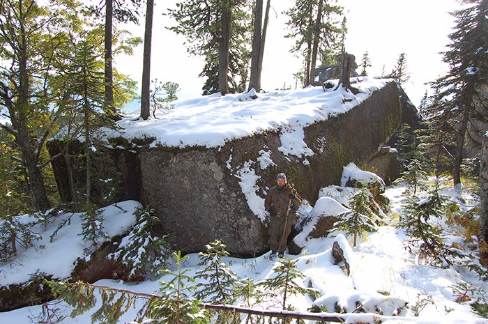
- The giant stone blocks have been raised to a height of more than 1,000 meters and installed there on a special platform.
- A strange cyclopean structure of vertically placed blocks stands on a giant foundation.
- The blocks are laid under a direct angle that the Nature never does.
- The height of the wall is about 40 meters, and the length of the wall is almost 200 meters.
- The length of the stones that make up the structure is about 20 meters, and their height is 5-7 meters. Each block weighs more than
.jpg) 1,000 tons.
1,000 tons. - Scientists are considering two versions of the origin of the structure: 1) it appeared in the time of ancient civilizations, 2) the found stones are the result of geological processes associated with the strong weathering of the rocks of Gornaya Shoria (Mountainous Shoria).
- At the top of the wall, there are traces of the ancient melting of the rock. It is clear that the buildings might have been destroyed by powerful thermonuclear or some other explosions.
- The arrows of all compasses deviate from megaliths. An inexplicable phenomenon of a negative magnetic field. It could be a residual phenomenon from ancient, antigravity technologies.
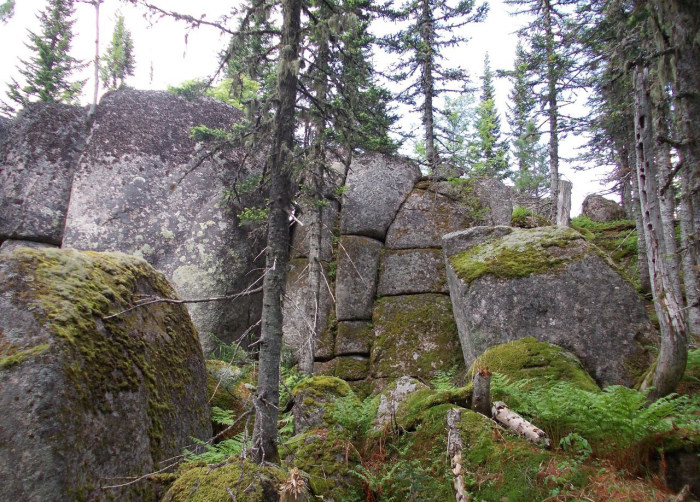


In Russia, there are many unique megaliths, but they are not so well known as English Stonehenge, Lebanon’s Baalbek, or Ollantaytambo in Peru. However, the Kemerovo region megalithic structures are considered to be the biggest in the world.
Here are two short videos on the Kemerovo megalithic structures: